
Myanmar Spring Chronicle – May 12 Scenes
MoeMaKa, May 13 2023
How are the preparations for the dangers of Cyclone Mocha?
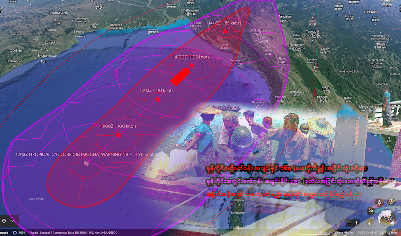
It is estimated that Cyclone “Mocha” will take at least 24 hours to a maximum of 36 hours to make landfall in northern Rakhine State on the west coast of Myanmar. Regarding the route of landfall, it is predicted between Sittwe and Cox’s Bazar, the border of Bangladesh, and there are also predictions between Sittwe and Kyaukphyu.
There is not only one storm forecasting system in the world, so forecasts vary slightly. Some estimates of the storm’s strength ranged from 105 to 135 miles per hour. Currently, the wind speed in the Bay of Bengal is more than 130 mph, and when it makes landfall, the wind speed may decrease slightly due to the mountains on the Rakhine coast.
However, the real concern is how many deaths will be caused by the Cat 3 cyclone, which will make landfall at a minimum of 100 miles per hour. For countries such as the Southeast Coast States of the United States, the Philippines, and Bangladesh, which are often affected by cyclones (known as hurricanes in some regions) in the world, the respective governments are able to conduct relief and evacuation measures to reduce the loss of life and damage caused by the storm to a certain extent. In Myanmar, due to the fact that such a powerful cyclone occurs once a decade, the current coup military is unable to really manage the areas, and the trust of the local people is declining, so it is worrying how much they will be affected by natural disasters.
The military council is only interested in defeating armed resistance attacks in the country, and most of the budget from the country’s resources and taxes is spent on military weapons and the cost of war, so it is not spent on prevention and relief before such a natural disaster. It has been 80% certain that the storm will hit northern Rakhine for the past 3–4 days, but the military council has not made any temporary evacuation plans for those living in the danger zone.
In Rakhine, only on the evening of May 12, there are pictures in some telegram channels showing that some military vehicles came out of their base and prepared for evacuation, but on the ground, only many photos of the Arakan Army helping the residents to evacuate, are seen. According to reports, as of the morning of May 12, the number of evacuees had not exceeded tens of thousands. On the evening of May 12, the military council declared 7 townships in Rakhine State as red-level danger zones. However, before the storm, there were no specific plans for rescue operations, and it is widely seen that the local residents are moving on their own volition and at the urging of the community.
In order to avoid the loss of many lives like Cyclone Nargis, it is important to take precautionary measures and temporarily evacuate from areas that are prone to disaster. On the other hand, the ability to provide information and assistance from administrative organizations that govern the area is important.
Apart from the fact that the intensity of Cyclone Nargis is slightly stronger than that of Mocha and the fact that the topography of Rakhine State is not flat and there is no high risk of life and death being inundated with water, the political and other situations in Myanmar are worse than when Nargis occurred. If any danger falls, it is seen that there is no readily available rescue for those who are in danger.
We will have to watch with concern whether the natural disaster will cause more trouble for Rakhine State, which has been lagging behind in development due to transportation barriers and the political stability of the region.