
Myanmar Spring Chronicle – May 11 Scenes
MoeMaKa, May 12 2023
Cyclone & Politics
About a week ago, news and social media posts about a possible cyclone in the south of the Bay of Bengal started showing day by day, and meteorologists have been informing people about forecasts and warnings through social media and Q&As.
The widely accessible internet and being able to present it easily through social media are significant differences when compared to the situation 15 years ago in 2008. Before Cyclone Nargis hit Myanmar’s Ayeyarwady and Yangon Regions in 2008, there was no widespread discussion among the public about the possibility, direction, and severity of such a storm.
In 2008, Myanmar already had an Internet connection, but most people are not yet able to access the Internet on their mobile phones at their houses. Even in a city like Yangon, it’s a time when people have to go to internet shops and use it. For small towns in remote areas, the internet speed is also very slow compared to now, and being able to use weather apps is unimaginable. It is a situation where we can only rely on government newspapers, TV, radio, and Myanmar news sections from abroad.
Currently, people in cities and rural areas have access to the Internet through their phones, so they can receive natural disaster alerts. It can be said that it is an advantage compared to 2008 that ordinary people can view the forecasts on the Internet, which are monitored daily by some Burmese meteorologists living at home and abroad, rather than relying only on the broadcasts of the state-owned media regarding weather forecasts and warnings.
It is an advantage because the public’s vigilance, the status of monitoring and listening to the natural disaster, and those who share the information and warnings on the Internet and social media in the neighborhoods and villages are also in the community. However, as an exception, the military council has cut off the Internet for months or years in areas where armed conflicts are taking place, so there may be a problem of not getting information in time for the locals in areas such as Paletwa and Matupi of Rakhine State, and the northern part of Magway.
What has been discussed up to this point is the part about receiving information and warnings about the natural disaster. After receiving the information, do we have the power to carry out rescue, relocation, storm protection, etc. in disaster-prone areas? At a time when the country has deep political divisions and a violent armed conflict, and due to the distrust of the local public in the government, like the military council, which controls the country’s power and manages the rescue and defense mechanisms, and the lack of conditions to connect with other areas because some areas are governed by PDFs like there is no military administration, the question of how they will evacuate and rescue a Category 3 cyclone with winds of over 90 to 100 miles per hour over the next 3 days has become unanswerable.
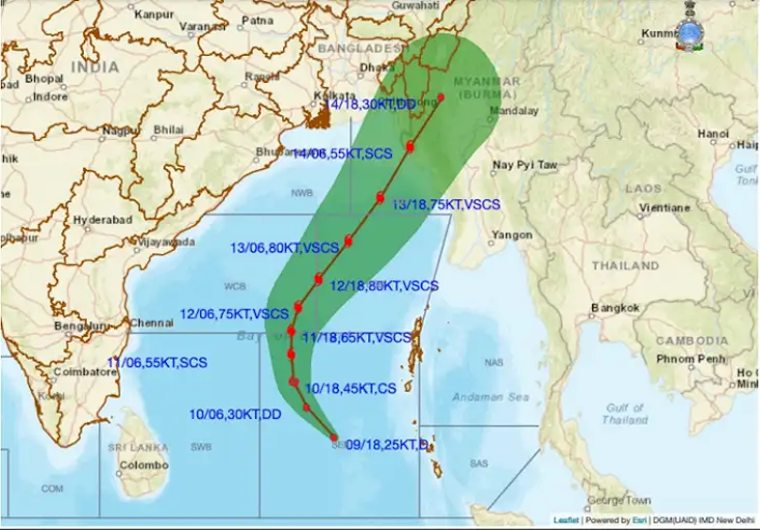
According to the latest forecasts, the cyclone named Mocha will make landfall on May 14th in Maungdaw, Rakhine State, and near Cox’s Bazar, Bangladesh. Rakhine is a poorly developed region that suffered from the 4-cut tactics of blockade by the military during the armed conflict in previous years, and Cox’s Bazar is where nearly a million refugees from Myanmar are taking shelter. When the storm hits the coast and landfalls, it is predicted that the storm may affect the Matupi region in the south of Chin State, which borders northern areas of Rakhine State and is also an area of conflict amidst armed battles. Before it weakens, it may continue to hit the northern areas of Magway as an inland storm.
According to the International Disaster Warning System, the number of people who will be affected in Rakhine State, Chin State, Magway, and Sagaing is close to 2 million. All of these 4 regions are regions where armed conflict is currently raging or has just begun.
When this storm is about to hit, there is no prospect of cooperation in disaster prevention, rescue and evacuation, after putting armed battles and conflicts aside for a while. Because these areas are subject to strict security checks and attacks, there are no reports of people evacuating from these areas until less than 3 days before the storm hits.
Currently, there may be no situation for preventive measures as there are limitations, such as the fact that the areas that are at risk of storms are not completely ruled by an armed group, and security and military restrictions are preventing people from going to the area to be evacuated.
The military council’s National Disaster Management Committee is chaired by Soe Win, vice-chairman of the SAC. Although they were holding meetings in previous days, it is probably no more than giving a warning to evacuate on the ground. When there is a risk of a natural disaster, it is impossible to find relief in Myanmar at present to move millions of local people to safe areas with the help of the government like in other countries that are not in a political crisis situation.
In the past few days, I have only heard that thousands of local residents from the areas bordering the sea in Labutta Township, where they were the worst affected by Nargis, have temporarily moved to Labutta Town on their own plans. There has been no news about evacuations in Rakhine, Chin, Sagaing, or Magway yet.