
Myanmar Spring Chronicle – Scenes from August 8
(MoeMaKa), August 9, 2026
Armed Conflict and Natural Disasters — or the Politics of Disaster
Meteorologists had forecast that from around the middle of this year through the beginning of next year, the El Niño phenomenon—a global climatic event associated with rising temperatures—could bring drought, reduced rainfall, as well as unusual patterns of precipitation.
Myanmar, too, is expected to experience the effects of El Niño to varying degrees. Even in years with relatively normal weather patterns, some parts of the country experience flash floods almost every rainy season, with rivers rising above danger levels and inundating homes, farmland and paddy fields. Such incidents have occurred almost every year.
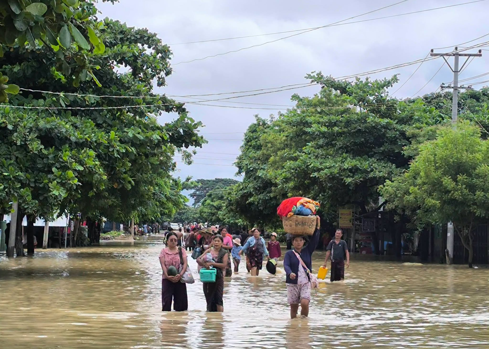
This year, however, abnormal weather conditions have brought widespread flooding, breaches of embankments, and the inundation of towns, villages and agricultural land. At the same time, in areas such as upper and central Sagaing Region, where armed clashes continue unabated, heavy rainfall and overflowing rivers and reservoirs have caused repeated flooding.
Several days after an embankment breached near Laymyethna in Ayeyarwady Region, heavy rains in Sagaing Region caused the Thaphanseik Reservoir to reach its full-water level. Excess water was subsequently released, flooding villages and farmland across areas along the Mu River in Sagaing Region. Six women farmers who were crossing a spillway without prior knowledge that water was being released were swept away and killed.
The areas currently affected by flooding include 14 villages in Kanbalu Township, around 20 villages in Taze Township, more than 50 villages including the town of Ye-U in Ye-U Township, 15 villages in Khin-U Township, around 20 villages in Depayin Township, 18 villages in Shwebo Township, 15 villages in Wetlet Township, as well as villages along the Mu River in Ayadaw Township. Altogether, more than 150 villages have been affected, with the number of people impacted exceeding 100,000.
Among these townships in Sagaing Region, with the exception of Kanbalu, the rural areas of nearly all the others are under the control of armed People’s Defence Forces (PDFs). The military controls mainly the urban areas of the towns named above.
Last month, heavy rainfall in northern Rakhine State caused rivers around Kyauktaw and Mrauk-U to rise, flooding towns and villages and leaving homes and buildings submerged for around a week. Because these areas are fully controlled and administered by the Arakan Army (AA), the Arakan authorities and the AA carried out emergency rescue and relief operations during the flooding in northern Rakhine.
The military regime, which now controls only Sittwe, Kyaukphyu and Manaung in Rakhine State, provided no assistance to the flood-affected areas in northern Rakhine. Nor did it ease its restrictions on transporting consumer goods, food supplies, fuel and medicines into Rakhine State.
During the current period of conflict, however, detailed information remains unavailable on how many people were affected by the floods in Rakhine State, the scale of economic losses and damage to agricultural and livelihood areas, or how much assistance the Arakan authorities were able to provide while simultaneously fighting battles along the state’s border areas.
Less than a month after the flooding in Rakhine State, an embankment holding back river water breached in Laymyethna Township, which borders Gwa Township in southern Rakhine State. It has now been ten days since water from the Ngawun River began flooding Laymyethna town and surrounding villages.
The floodwaters entering through Laymyethna Township are no longer confined to the township itself but have spread into neighboring areas, including Ngathaingchaung and Kyonpyaw townships. According to information released by the military regime, more than 40,000 people have been affected by flooding in Laymyethna Township.
Unlike conflict-affected areas, there are no major restrictions on access to Laymyethna Township. As a result, social welfare and rescue organizations from elsewhere in Ayeyarwady Region, as well as groups from other areas such as Yangon, have been able to travel there and provide assistance.
Military leader Min Aung Hlaing, meanwhile, visited Pathein only on August 8, the day after returning from a trip to Thailand. From there, he surveyed flood-affected areas by helicopter and urged business tycoons with close ties to the authorities to contribute donations for flood relief, while also overseeing the collection of donations.
The breached embankment that caused the flooding in Laymyethna Township has still not been repaired. As a result, the water that has already inundated the area could remain for months.
In recent days, Sagaing Region has become the third area in Myanmar to suffer major flooding this year.
Most of the flood-affected areas in Sagaing Region are controlled by PDFs and administered by People’s Administration Teams (Pa-Ah-Pha) under the National Unity Government (NUG). It is therefore almost certain that the military regime will not undertake flood rescue or relief operations in these areas.
Even three days after the flooding began in Sagaing Region, there had been no public announcement from the military regime. On the NUG side, the Ministry of Humanitarian Affairs and Disaster Management has issued an announcement and appeal regarding the Sagaing floods, but it remains unclear how much assistance is actually being provided on the ground.
Security restrictions on travel between different areas of Sagaing Region are also likely to make it difficult for social welfare and rescue organizations from other parts of the country to enter the region and assist flood victims.
In the past, when natural disasters such as floods struck Myanmar, people did not have to contend with circumstances like those of today—ongoing warfare and severe security restrictions on movement across territories.
Now, however, floods are striking areas already engulfed in armed conflict and exposed to the threat of aerial bombardment.
Should this be described simply as one disaster compounded by another? Or perhaps the reality has become so overwhelming that it is difficult to find words that adequately convey the scale of suffering.