
Myanmar Spring Chronicle – March 28 View
Moemaka, March 29, 2025
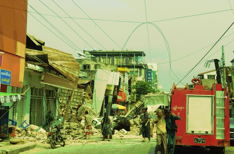
Myanmar Faces Its Worst Natural Disaster Amid Ongoing Civil War
It started subtly, like a slight jolt while sitting on a stool. At first, it was unclear whether it was just a mental glitch or a real earthquake. But as the door panels began to sway left and right, the reality of a tremor became undeniable. The vibrations intensified slowly, and people could see adjacent buildings and trees swaying, vehicles rocking back and forth, and the ground trembling noticeably. The earthquake lasted nearly a full minute—longer than most have ever experienced.
Soon after, social media began filling with reports and footage of the quake.
At a time when Myanmar is already ravaged by civil war—with tens of thousands killed and entire towns and villages burned and destroyed by airstrikes and shelling—one of the strongest earthquakes in a century struck at 12:50 PM Myanmar time on March 28.
Cities reporting deaths, injuries, and structural damage include Mandalay, Sagaing, Kyaukse, Pyin Oo Lwin, Naypyidaw, Taungoo, Aungban, Yamethin, and Wundwin. Among these, Mandalay, Sagaing, and Naypyidaw appear to be the hardest-hit.
Initial reports from seismological stations suggested a 4.9-magnitude quake centered in eastern Shan State near the Thai border. However, further data revealed a much stronger 7.7-magnitude quake centered near Ngazun. Aftershocks were later recorded near Pyin Oo Lwin and southern Shan’s Yatsauk area.
Dramatic videos flooded social media: hotels collapsing in Aungban, multi-story buildings collapsing in Mandalay, parents carrying children across the road just before a nearby building crumbled, and workers in Bangkok fleeing collapsing construction sites. Footage also showed cracked roads and destroyed homes in Pyin Oo Lwin, Naypyidaw, and Taunggyi.
Photos emerged showing the collapse of historic walls in Mandalay, and the collapse of the Ava Bridge—built post-WWII as Japanese war reparations—connecting Mandalay and Sagaing. Bridge pillars had crumbled into the Irrawaddy River, and water was flooding surrounding areas.
Hours after the quake, no official damage estimates were released. Rescue operations from the junta were nowhere to be seen. Motorbikes were toppled, some injured by falling objects, and eyewitnesses reported chaos and lack of coordination.
The junta’s rescue efforts were limited and mostly absent in the worst-hit Mandalay. Only regime-aligned media reported Min Aung Hlaing visiting damaged areas in Naypyidaw, but such efforts were not evident elsewhere.
In Naypyidaw’s Ela Airport, part of the control tower collapsed, killing air traffic control staff. Mandalay University was reportedly on fire, and several religious buildings also collapsed, including the Masoyein Monastery where monks were taking exams, causing injuries and possible deaths. Shwebo’s mosque also collapsed during Friday prayers, with reports of fatalities.
A viral social media post later in the evening reported 120 deaths. One condominium in Mandalay reportedly sank four stories into the ground, leaving only seven of its 11 floors visible. The actual number of casualties remains unknown.
By evening, the junta officially confirmed 144 deaths. Ironically, more deaths were reported in Pyin Oo Lwin, Kyaukse, and Naypyidaw than Mandalay—raising concerns about underreporting and ineffective rescue in Mandalay.
The real death toll may be many times higher. Damage to homes, hospitals, schools, and infrastructure remains unaccounted for, and the quake has dealt a massive blow to an already war-torn country.
Some political figures are calling for this moment of national tragedy to become an opportunity for dialogue among warring parties. They urge armed groups to pause and talk, out of compassion for the people.
But hopes for such unity remain dim amid ongoing political and military fragmentation.